

When our backpacking club, DCUL, hiked a section of the Appalachian Trail south of the Shenandoah National Park last year, we called our trip: “Whale Watching in the Blue Ridge Mountains.” It was really just a joke, though. Whales rarely hide in the trees of those mountains. We simply riffed off the name of a major rock outcropping along that route—“Humpback Rocks.” However, when we recently thru-hiked the “Foothills Trail” on the South/North Carolina borders over Memorial Day Weekend, we had concerns about thunderstorms, hot and humid weather, and bugs. We had zero concerns about “man-eating fish.” Ah! How naive we were . . .
Most of us never before knew of the Foothills Trail until Karan (“BA”) proposed thru-hiking it over the holiday weekend. DCUL is famous for picking a long trail in Pennsylvania at this time each year and hiking the thing. And, indeed, Michael M (“Uturn”) organized a group to thru-hike the 70 mile Laurel Highlands Trail east of Pittsburgh, PA; and Kyle (“Water Dog”) took a group across the 85 mile Standing Stone Trail south of State College, PA. However, BA was itching to venture south this year, and six others of us agreed. This trail should not be the secret that it is; it is easily one of the most spectacular trails of the mid-Atlantic mountains. I rank this trail within the top 5 that I’ve hiked.
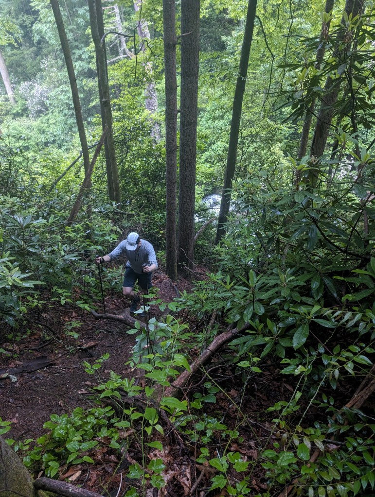
The Foothills Trail is a 77-mile long trail south of Asheville, NC along the borders of the two Carolinas, touching the border of Georgia for a while. Extremely well maintained and marked, it passes so many epic waterfalls that one eventually grows weary of waterfalls. It passes so many varied landscapes that it serves as a reminder of (or preview to) the environment of all the other regions of the mid-Atlantic. At times it reminded me of parts of Virginia, Pennsylvania, West Virginia, and New York. If you want to hike a single trail to get a feel for the mid-Atlantic mountains, this is your best bet. The Foothills Trail is an unfortunate name for this trail. The name makes one imagine a gentle stroll, not the intense physical effort one must really make to complete the trek.
We chose to hike west to east on the recommendation of Juliana (“Chaunce”) from the podcast she co-hosts, #BackpackerRadio. She recommended this direction because “the views build” and because it is best to end the hike with the 4 mile descent to Table Rock State Park instead of starting it with an ascent. She was right.
We set up a commercial shuttle with a driver who picked us up Friday morning from Table Rock State Park, the eastern terminus, to drive us to Oconee State Park, the western terminus, to start our hike. Along the long drive, he warned us about how difficult this trail is, and highlighted all the potential bail-out spots along the way. Charmingly, he described how often he dropped off hikers only to pick them up again mid-trail as sniveling shells of their formers selves. Before relaying each hazard he prefaced his statement with “I feel obligated to tell you,” as in “I feel obligated to tell you swimming the river from South Carolina to Georgia could be deadly.” He mentioned the deceptive elevation gain/loss, frequent weather changes, and I think he mentioned at least one dangerous animal. He highly recommended that we extend our parking passes for a day longer than planned because so many hikers who complete the trail do so a day late. I asked him, hopefully, if we had to worry about armadillo stings, as I eyed Logan (“Scorpion”) sitting behind me. I previously read that armadillos roam the Foothills Trail. My friend, Scorpion, recently survived a sting from from a scorpion the previous month on the DCUL trip to southern Utah, earning the right to that terrific trail name, but declining it. (I’m using his rejected trail name for this trip report under literary license). I figured that if he got stung by an armadillo on this trip that he might claim the trail name “Sting.” However, our driver reported never having encountered armadillos so he did not feel obligated to warn us from them. We rolled our eyes at each other as he described his parade off horribles, just as bullet-proof Superman would roll his eyes if someone told him how dangerous bullets can be. Our driver could not know that we were the lean, mean backpacking machines we are!

We began hiking around noon on Friday, instantly sweating in the sticky hot, humid air. We hiked almost 15 miles with over 2,500 feet of elevation gain, but it felt easy. We passed some waterfalls, any one of which would be a trip highlight on most trails. The big ones were Lick Log Falls and Big Bend Falls. As the trip progressed, the waterfalls became increasingly spectacular and frequent. I took pictures of most of the major falls for documentary purposes, but there were too many and they eventually caused beauty overload. Those who hiked the canyons of Utah or the mountains along the Pacific Crest Trail know the condition—observing non-stop natural beauty causes scenic weariness and callousness. “Oh, just another epic once-in-a-lifetime waterfall view. Yawn.” We dutifully took photos of each anyway. We made camp along the Chattooga River after hiking 15 miles on that shortened day.
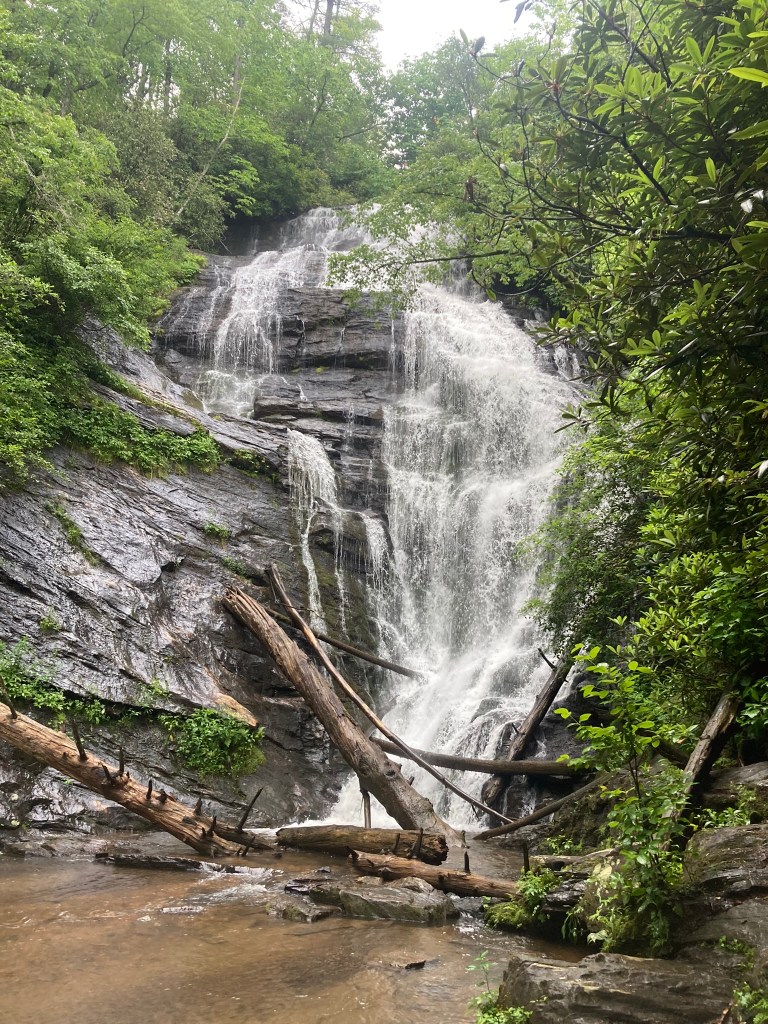


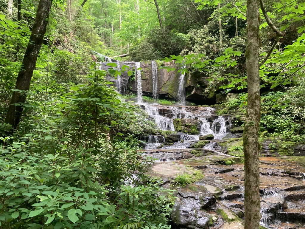

Saturday and Sunday followed the same pattern, albeit it with longer miles; 21 miles and 22 miles each day. A fast crew, we started hiking each day after sunrise and made camp long before sunset. The trail has significant elevation gains and losses. Some may find it frustrating to work so hard to climb to elevation only to immediately give it back on a descent. The trail maintainers know this. They even called one such section “Heartbreak Ridge” because of the steep staircase of over 1500 feet of immediate gain and loss. The waterfalls became grander and grander. At the largest one, fittingly named “Whitewater Falls,” we had a great lunch on the platform overlooking the wall of water. We talked with a number of day hikers and met another thru-hiker, Carl (“Foxy”). A former Appalachian Trail thru-hiker, Foxy was solo hiking the Foothills Trail. He was one of the few other thru-hikers we saw on this trail.

Along the way we reveled in the wet jungle-like environment. Thick, green foliage lined the trail—many with flowers. Streams flowed everywhere. I stopped carrying more than a quarter liter of water at time because more was unnecessary. Despite this Jurassic-like environment, the trail maintainers are so amazing we rarely brushed up against foliage or got our feet wet. The trail was cut wide and comfortable. Usually, it was well-graded. Bridges were everywhere. But for the rain on Sunday and Monday, we would never have had wet feet. A wonderful cruising trail, we hiked as a group at a very fast pace. One of us, Steve (“Baconator”), eschewed the pack line for the opportunity to take long breaks at the waterfalls.
Everyone went swimming at various times. Justus (“T-JAW”) chose to risk the swim across the Chattooga River, the border of South Carolina and Georgia, so that he could say he visited Georgia. A German citizen working in the US for the year, he became the first German to ever successfully swim between the two states as far as I know. Despite our shuttle driver’s warning about this swim, he survived without any difficulty.
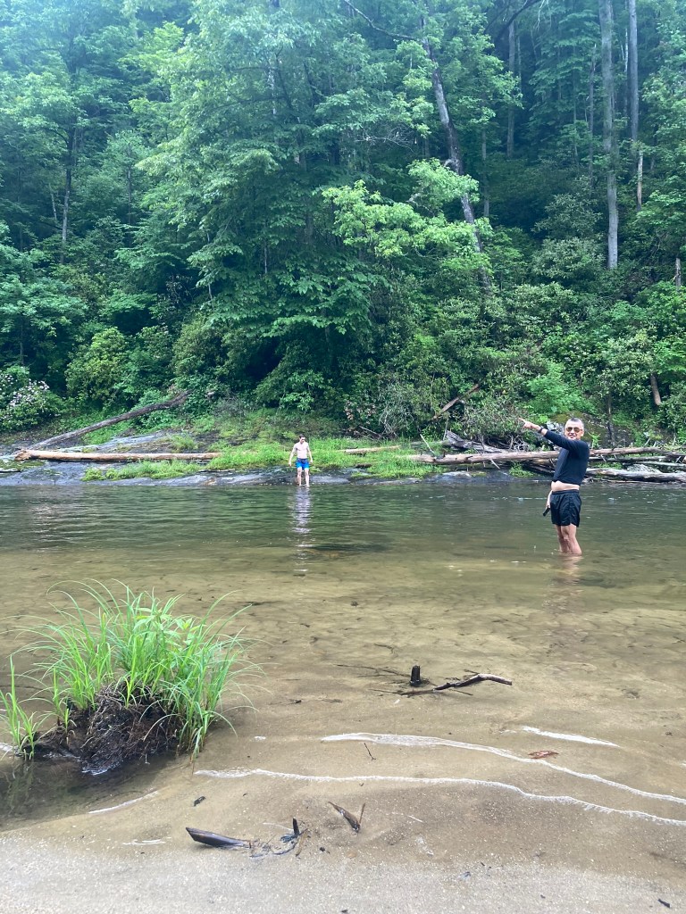
Haigang (“Two Gang”) seemed to strip down and go swimming at every stop we made to cool down in the clear, cold waters. Everyone else joined him at the Toxaway River confluence with Lake Jocassee, where we stopped for lunch. We ran into Foxy during lunch. He sadly announced that he was ending his trip early because his knee was hurting too bad. His plan was to flag down one of the many boats on the lake to float him to a place where he could call for a shuttle back to his car at Table Rock SP. He offered us a terrific parting “trail magic” gift. He volunteered to pack out any of our trash. It is amazing how much trash emerged from our six backpacks. I think we need to plan meals with less packaging—this stuff adds up.
Our many swimming and soaking stops were the simple, innocent, refreshing affairs one expects in the summertime mountains. Man-eating fish was not on any of our minds. They should have been. At a stream along a campground near the Virginia Hawkins Falls, we stopped for snacks and yet another cooling dip. I was the first one into the creek, which was mostly no deeper than knee-deep. I smiled as my feet cooled in the clear, cold stream. It felt great. Suddenly, I heard some low, bass music notes in the distance. Daaa dum. Daaa dum. I looked around, but saw nothing. Daa dum. Daa dum. “Hey, do you guys hear that?” I called out to BA, Kylie (“Faceplant”), Two Gang, and T-JAW. They stopped talking, listened carefully, and shook their heads “no” curiously. The bass notes started coming faster and louder. Daa dum. Daa dum. Da Dum, da dum da dum da dum da dum—and then I felt it! Fish were eating my feet! When I saw what was happening I started screaming and ran to the shore, water splashing everywhere like a tornadic waterspout as the bass sounds increased in volume and tempo. My friends rose and rushed to my aid.
Actually, I did not scream and run. (My trail name is “Spider-Man,” after all). I felt and then saw tiny minnows nibbling at the dead skin on my feet. It felt like slight, painless pinches. I’ve experienced this before on a trip to Mexico. I’ve also seen “fish pedicures” as an expensive spa menu item that I’d never pay to enjoy. My friends took off their shoes and joined in on the experience. BA took a truthfully unposed photo of us standing in the stream, looking down in wonder at the fish nibbling on our toes. T-JAW spotted what he called a “shrimp,” but what us southerners know are “crawdads.” It did not nibble on his toes. I smiled thinking about how I can now claim I “survived” an attack by literal man-eating fish!
Man-eating fish were, indeed, the least of our concerns. Managing rain was the larger challenge. It rained each night of our trip—often very hard. It always amazes me how heavy a backpack gets when you add a wet tent and clothes to the mix. It also rained hard a good part of two days. Hiking in the rain was not too bad for me. I had my TRDD (similar to an umbrella) and rain kilt to keep me dry without overheating. Most of the others did so, too. This is really the best way to manage rain. Two Gang and Baconator hiked “old school” in rain jackets; T-JAW just wore shorts and a t-shirt, accepting his deep soaking and keeping warm by hiking at the speed of a light jog. At breaks in the rain we were able to dry out our wet gear in the sun. It is amazing how fast things dry out in direct sunlight.
Our last night and day featured the worst of the rain. At night, the rain hit us right at dinner time. We dove into our tents hoping to wait it out, hungrily praying for a break to allow us to start cooking. Baconator, who had continued hiking with his regular rest breaks, arrived at camp in the hard-driving rain. He set up his tent in that condition which always leaves one damp. It is much nicer to set up a tent before the rain. Then, to our delight, the rain stopped. We emerged to begin cooking. I completed cooking and was just about to take my first bite when Scorpion stated dryly, “uh oh, here it comes again.” Suddenly rain started dropping on us like buckets of water. We each grabbed our dinner gear at the various stages of completion and dove back into our tents. Baconator abandoned his food and cookware at the unlit fireplace that we used as our dining room. He would ultimately eat what he could under his leaking tarp, risking the food he left behind at the fireplace to the appetites of the native wildlife. BA and Faceplant happened to have chosen the best camping spot, perched on a small rise above the campsite. Their ground was reasonably dry. The rest of us “lowlanders” unfortunately pitched our tents in bad spots. We sat as the rain noisily pounded our tents, increasingly alarmed at the rising water on the ground and from the splashes from the hard drops. I could feel flowing water under the floor of my tent and could see the waters lapping up the sides of the “bathtub” sides of it. With my hands I raised the sides an inch to prevent the water from entering my tent. It worked, but it made eating my cooked dinner challenging because I had to keep holding the floor up with one hand, leaving me only the other hand to use for eating. We all remained in our tents way too early in the evening. It rained on and off most of the long, long night.
The last day started promisingly. The rain had let off, with only the gentle irregular patter of residual drops from the trees falling on us. Baconator reported that his Dyneema tent failed—it was no longer waterproof. He declared that everything he had was wet. Worse, an animal got into the dinner he abandoned the previous evening due to the rain. (I think I spotted a small chipmunk smiling and picking his teeth with a toothpick in the nearby brush). We originally had planned to spend one more night on the trail, but resolved to just hike through that day and finish the trail a day early. By hiking more miles than we planned each previous day we only had 19 miles left to hike, anyway.
This last day was challenging. The rain picked up again and the temperatures dropped to the mid 40s. Uncharacteristically for a morning rain shower, it was also thundering with distant lighting flashes. My fingers began getting cold enough that I considered stopping to put on the pair of mittens I brought for just this occasion. At one point, the trail descended a steep hill and I reached a small parking lot. Two Gang had been hiking just in front of me and he and I dashed to a small covered park sign. We stood side-by-side with our backs to a map of the region and the heavy rain falling inches from our chests. We enjoyed the momentary oasis from being directly in the rain. T-JAW soon came off the trail and joined us in the lineup.
A pickup truck pulled up. In the passenger seat was Foxy! He had called for a shuttle to extract him from the trail and his driver thought to come up to this parking lot to see if anyone else wanted a ride off the trail. I’ll confess: I’m a strong hiker and was reasonably warm and dry, but the offer was tempting. Baconator, who was not there at the time, later declared that he would have probably accepted—depending on the price. We declined, thanking Foxy and his driver. I jokingly asked if Foxy would accept a bit more of our trash from the prior night. He readily agreed, but it was more work to dig the few scraps from my pack than it was worth. We bade each other farewell.
Our trek for that day called for us to scale Sassafras Mountain, the highest point in South Carolina with the most challenging climb. Before the climb up that mountain, there was a smaller one below it to go up and down. I was moving fast to keep warm and getting tired on the small mountain before Sassafras. It was intimidating to consider that if this smaller mountain was so challenging that Sassafras must be exhausting. Breathing heavily, and my arms fatigued from holding my TRDD, I came around a bend and saw T-JAW and Two Gang crouching below a rock overhang to be out of the rain. T-JAW decided to change his strategy of just getting soaked in his t-shirt and shorts and, instead, don a dry shirt and rain jacket. Two Gang was boiling water for a hot drink. I considering stopping to rest with them, but was concerned that doing so would make me too cold. I find that keeping my core temperature stable in cold rains makes me feel better. Once my core temperature drops and I start shivering I find that it takes a lot of time before I can warm myself up again. I glanced at my gps to see how far I was from the bottom of the Sassafras Mountain climb. To my delight, I learned that I was near the summit of Sassafras. I had been climbing Sassafras the whole time! I left my friends to summit, which I did alone.
At the top stood a huge concrete viewing platform. However, looking around, there was absolutely no view. It was as if my friend David (“Baseball”) planned this trip. He usually plans trips with epic views for days when rain clouds completely obscure the view. While there was no lighting by this point, there was still distant thunder. It made no sense to me to climb the viewing platform in a thunderstorm to see nothing. So, I continued on the trail.
After a time, the rain stopped. It did not taper off. It just instantly stopped. I heard the birds. I felt some of the bugs. The temperature rose to the high 70s and the humidity amplified the heat. I went from wishing that the rain would stop I’m to hoping it would restart! I began getting wetter from sweating that I had from the rain.
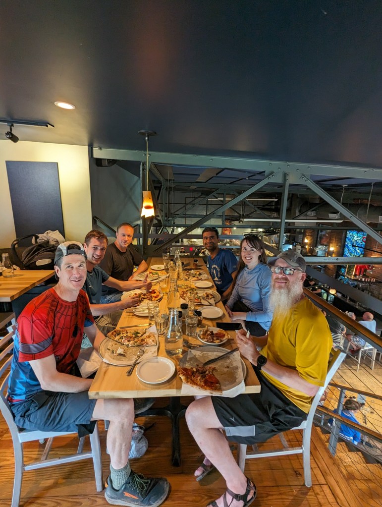
I reached a slick rock outcropping overlooking Table Rock State Park. I pulled out my drenched tent and spread it out along with my damp clothes to dry in the sun. I sat in the pleasant shade overlooking the valley. T-JAW soon arrived and started drying his gear, too. BA, Faceplant, and Scorpion who had taken a break deep in the woods just moments before decided to join us for their second break. Baconator was not far behind, having decided to forego his previously frequent breaks. He was cold, wet, and done. Without stopping for more than a group photo, he continuing hiking toward the end of the trail.


After our break, we chased after Baconator to complete the trek. At the bottom of the mountain BA, Faceplant, and T-JAW took one more swim in the last waterfall of our hike. Many hikers take 5-10 days to complete this trail; we did it in less than three and a half days. But, of course, we are DCUL-strong!
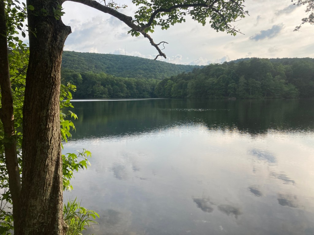
Not wanting to shorten our vacation just because the Foothills Trail is too short, some of us planned overnight trips before and after the thru hike. Before hiking the Foothills Trail, Baconator and I hiked many of the trails at the Paris Mountain State Park, on a delightful mountain just outside Greenville, SC and only 20 minutes from the airport. We spent a night on that mountain, camped along a mountaintop lake. Of course, it rained that night.
After the Foothills Trail, T-JAW and I camped at Table Rock SP, waking at 4:00 a.m. so that we could climb the mountain to the eponymous slick-rock outcropping to watch the sunrise over South Carolina. It did not rain that night and the dark pre-dawn cool weather made the 3.5 mile, 2300 foot climb much easier than if it was hot and humid.
At the top we sat down breathing heavily as I announced, “ok, let’s start the show.” The skies increasingly reddened. The sun yawned awake with an amazing light show against the deep valley with pools of mist below us, and on the nearby rock cliffs along side us.

With the day firmly established, we climbed down the mountain in silence, only seeing two other people as we neared the bottom—a couple in their 60s just starting their ascent. I smiled as I told them as we passed: “we saved some view for you.”
—- David O (“Spider-Man”)
If you go:
Here is the CalTopo track we used.
(However, we hiked faster and further each day than planned, so each camping site was further than plotted).
Here is the Meetup posting BA advertised.
Half of us drove from Washington, DC—a looong drive. Those who drove broke up the drive by camping in southern Virginia campgrounds along the way down and back. Three of us flew and/or took the train. We all flew out of Greenville, SC. It was slightly closer to use Greenville than the airport at Asheville, NC. However, Greenville airfares were cheaper at the time we booked. The train takes way too much time. T-JAW was on the train all night.

“We chose to hike west to east” doesn’t seem to match up with “picked us up Friday morning from Table Rock State Park, the western terminus, to drive us to Oconee State Park, the eastern terminus”.
LikeLike
Sting!! What a great trail name! And Logan does need a trail name. It’s been way too long.
LikeLike