
It’s nice when a trip exceeds and then far surpasses your expectations. To be honest, I had no idea what to expect with our trip there. I had researched loops near Las Vegas, and Death Valley’s Cottonwood / Marble Canyon loop kept coming up to the top of the list. The pictures of the slot canyon looked stunning, and while the loop was short, the route-finding aspect gave it additional interest. So on the calendar it went, and off we went to sunny Las Vegas.
We had a group of 10 for the trip: me, Michael, Marika, Iru, Peter, Andrew C., Aileen, Brian, Max!, and Dave. We gathered in Las Vegas Thursday night at the Grand Lux restaurant in the Venetian. Michael and I had flown out a few days earlier to check out the Consumer Electronics Show. Vegas was nice but we were ready to head out and get started.
The drive from Las Vegas to Death Valley is an easy one. We were on the road early in the morning, aiming to arrive at Death Valley before noon and have an afternoon to explore some of the more popular sites before starting our backpack the following day. But first, registering at the visitors’ center—we needed info for all the cars and for all the people, backpack colors and types of tents. I somehow managed to fit information for 10 people onto one form.
And next, intel on the water situation. Death Valley, as you might guess, is not known for its abundance of water. Our route had three possible water sources, which I described as probably dry, flowing, and maybe dry. But while water is often an issue, a storm had swept through the area earlier in the week. Maybe the springs would be in better shape? Still, we decided to err on the side of caution and assume we only had one water source, which meant we should carry all water needed until camp for day one, and then tank up there so we could carry all water needed for day two and three.
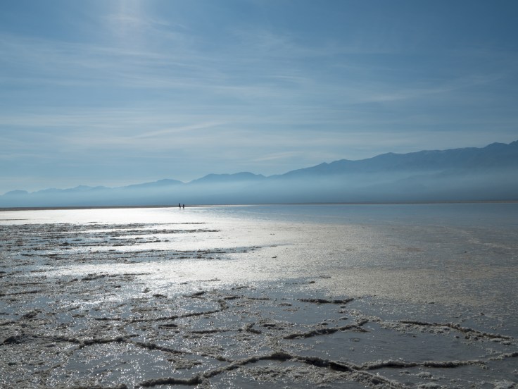
Now for tourism. I had originally wanted to check out the Racetrack, but the roads there, as the park ranger said, were in very bad shape. Andrew had a list of places to see if you only had one day, so into the cars and off we went. For me, Badwater Basin was the highlight of our tourism day. We gathered with the crowds to watch the sunset by Zabriskie Point, and then drove over to the Badwater Saloon for dinner.
Friday night, we camped at Furnace Creek, a call I’m glad we made. The main reason was because it was one of the few campgrounds that could be reserved in advance but the sites were pleasantly large and well-spread out. A fire, good conversation, and then we all made our ways back to the tents.
Waking up on Saturday morning, I was a bit confused about the water dripping alongside the Trailstar. We had the most condensation I’ve ever seen: all of our tents were nearly soaked. So much for the desert being dry, we chuckled, as we packed up our gear.
And now to backpack. Well, the drive to the backpack. Our three SUVs started to make their way down a sandy and bumpy road. Our hope was to make it to the trailhead but the roads are notoriously bad—SUVs are recommended, and frankly, I wouldn’t want to make the drive in anything else. We got within a mile of the trailhead before we stopped and parked, mainly because we felt that we had pushed our rental cars far enough.
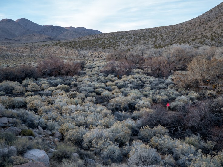
Cottonwood Canyon was our first stretch—after the trailhead, you follow the road for seven miles before it ends and becomes foot traffic only. As suspected, the stream there was flowing because of the rain, but it’s rare and shouldn’t be relied on. From this point, the canyon narrowed a bit, and the trail led you past cottonwood trees and then up and over a rocky notch. To be honest, the trail had been so mild up to this point, it almost seemed a shock that we had to climb.
From there, we could see our campsite at Cottonwood Springs below. Michael and I had decided to cowboy camp that night—not wanting to deal with condensation again—so we set up our sleeping pads and bags, and filled up water at spring. Max! had packed in 20 beers, and 10 were eagerly consumed that evening. Michael and Andrew enjoyed some astrophotography. And then, time to sleep, at least for me.
In our streak of surprising weather, this night got cold. So cold that our water froze, which we were not expecting. We anticipated that temperatures could get close to freezing but it certainly dipped well below that point overnight.
Day 2 promised to be a little more adventuresome, as this was our route-finding day. This section between Cottonwood and Marble is technically trail-less, and you need to navigate yourself over the correct ridge to ensure you drop into the right canyon. The National Park Service supplies GPX files for this route, which a number of us had loaded onto our devices. From our research, we knew there was a tricky bit just past that ridge. We decided to stay together, but it was easy to do so in that long valley. I could see Aileen’s pink form bobbing along ahead of me and Marika’s purple to the back of me. We all made our way down the valley and to the correct ridge. We all marveled at the fact that we were near 5,000 in elevation after being at sea level—or below—just the day before.

We made our way down, keeping an eye on our GPS line to make sure we kept heading towards the correct ridge. When you get to that point on the trail, it is easy to see how you could make a mistake. You want to keep to the right and head down, but the correct route is to the left and then over one more ridge.
But we had one more challenge ahead of the us. Our descent into Deadhorse Canyon had two options, with the GPS line taking a deep plunge down a gully and a lovely trail leading down a still steep but somewhat graded path. We opted for the trail after confirming that both options would arrive at the same spot, and quickly arrived at Deadhorse Springs—and yes, it was flowing.
Our next obstacle was the much-heralded deadfall that we need to climb down as we entered Marble Canyon. It wasn’t quite as formidable as described, and Dave offered a helping hand to anyone who wanted it.
The trip had been great up to this point. From here, it became outstanding as we entered the three sets of narrows that make up Marble Canyon. It’s one of the best days of backpacking that I’ve had, and we all made our way slowly through the area.

Once out of the canyon, we set up camp at one of the sites along Marble Canyon Road and celebrated by drinking the remaining 10 cans of beer. Michael and I cowboy camped again, and I woke up early enough to see the International Space Station zoom across the sky before the sun rose.
This is definitely a route worth doing.

Leave a comment