“So, at that point, we were scattered all over the countryside. Emily and Janice had pulled over to camp near Blackwell; Holly was at a hotel in Jersey Shore after getting her leg stitched up; Spider-Man, Logan, Reid, WB, and I had climbed back up the plateau north of Blackwell … Oh, and no one had seen B~~~ all day and really had no clue where he was.”
”So, you’re saying it’s just like every other MST section?” replied Jen Adach.
Perhaps, dear reader, perhaps. But this one did get a little hard, harder than intended. As you may know, we set out to section-hike the MST this year, in five sections rather than the seven I used last time. But I had intended that we would try to keep the full days a little easier. Much like last time, we’re discovered that the farther we get north, the more difficult our set ups become. I suppose I underestimated how much time they would take.
In any case, Friday, 8/29, we headed north from DC. I met Emily at King Street and we left at 7am, which meant that we all started very early. Holley, Janice, Logan, Reid, WB, and B~~~ all arrived at Tannery Hill Road in good time (the road was fine, even for my car), but we had the cache to establish at Hackett Road, then get back all the way to Ram Road, south of Jersey Shore. We weren’t hiking till 3pm.
Somehow, I had budgeted that we would get 25 kilometers (16 miles) before dark—it rapidly became clear that was a tall order. We communicated up and down the line to stop at Big Spring, just 21 kilometers (13 miles) ahead. We went over Roundtop, which was rugged and overgrown in spots (though someone had done some heroic work to put in some switchbacks near the end), then along the cornfields bordering the West Branch of the Susquehanna River. B~~~ and I remarked about how this experience was such a contrast to the last time, when we did this stretch in terrible heat. Over the river we went and through Woolrich, where a previous section had ended. We lost the blazes climbing out of town, but found them a bit later. Night fell and the headlamps came on. The Mid State Trail is tough hiking in the dark, I can report. But we quickly came upon good camping sites in the Big Spring area. Tired (I had been hiking four hours with no break), we camped in a few dispersed sites. Spider-Man caught us there: he had been able to start just an hour later from Ram Road.
But camping early meant that Saturday would be more difficult, as our cache was almost 40 kilometers ahead (24 miles) and there was something in the vicinity of 2,000 meters of gain (roughly 6,000 feet). What idiot plans these things, anyway? It was going to be a long day, so we started early, before 7am for me. In the crisp morning air (we had great weather all weekend), we enjoyed easy plateau walking and then a stout descent into Gamble Run. Then, the climbing started. Back up to the plateau. Then, the negative self talk started. A rough descent to Pine Creek and easy walking on the bicycle path. Another big climb, down along a gully, climb again … than a long side hill along Pine Creek to reach Happy Acres Resort.
I ambled in there around 4pm, I think. I drank a Yuengling and got my water bottles filled. People were watching college football and getting soused …it felt like a Labor Day weekend along the MST, which it was. I could have stayed there all night … but another climb beckoned … Up, up, up, I went, but at the top, I decided I’d use some guile. I turned left off the MST, crashed through the brush to some country roads, and matriculated my way to Hackett Road and our cache. As I strolled along in the fading light, I basked in the warm glow of my own cleverness. Always a great feeling.
(For the record, though my line on foot from Maryland is unbroken, this bit of cheating meant that I won’t formally finish the MST unless I go back and get these few miles. That’s okay: I’ve done the trail before and the impromptu navigation was fun for me. If I want those few miles, I can always go get them.)
Anyway, I wanted to get to the cache faster, which I did. We drank a few beers and ate ice cream as people trickled in. Holley ended up camping just a few hundred yards short; B~~~ we knew had planned to pull up Love Run. This had been a tough, tough day. Spider-Man said it was more difficult than a four-state challenge. I’m not sure I’d go there … I couldn’t walk after my four-state challenge completion, but this had a lot of verticality to it. The route that I walked took me about 12 hours—if I had done the last dip, it would have been 30 minutes or an hour more.
The next morning, Holley came up from her campsite. She had fallen and gashed her leg badly. She decided to get to a doctor for stitches.
So, she passed her keys off to Spider-Man and descended to Pine Creek, where a ranger gave her a lift.

Sunday was supposed to be an easy day, just 25 kilometers (16 miles) to Big Run Road. Do you think that’s how it went?
In the morning, we enjoyed the easy walking along the plateau. The last section hike, we had done this stretch on a brilliantly cold Columbus Day weekend and I remember us all cowboy camping in a field. This was warmer and dry, but still nice. We took a lot of breaks and did not hurry: I think we were a little beat up from Saturday. We passed a rather strange property line before Big Run … where the campsite was definitely too small for us. Logan etched a message in charcoal.

I do think we could have camped at a disused fire road shy of Gillespie Point, but we were scattered and I didn’t mind getting some more of this climbing behind me. On top of the Matterhorn of Pennsylvania, I washed down some vitamin I with a beer. Then we rallied in Blackwell.
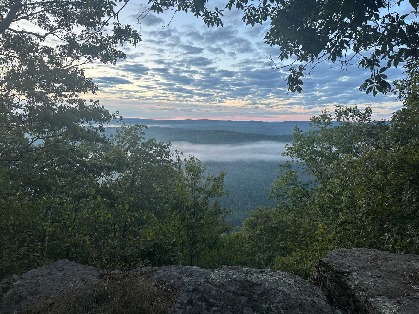
Blackwell has its limitations as a trail town. You can’t get a beer; you can’t get a meal; you can’t camp; you can’t get a room. I knew, once we left Big Run, we were doomed to have to climb back up to the plateau. Emily and Janice decided to stay at the nearby campsite maybe 1.6 km (1 mile) away. Reid, Logan, WB, Spider-Man and I chugged our way up the steep climb out of Blackwell. We collapsed at the top, where we enjoyed a truly beautiful campsite, which included both sunset and sunrise. We got a message from B~~~.

He joined us after a bit. He had a rather epic day to catch us. We were exhausted and slept.

Monday morning, we still had some hiking left. I started early, but I admit I was tired. The others reeled me in fast. We did the plateau, we strolled along the Stoney Fork Run—a beautiful place. We climbed for the cars. Everyone could smell the barn.
From that point, it was all over except for the driving. Emily and I collected the cache and ate at the hotel in Slate Run. The others got Holley, reversed the shuttle, and I think ate together in Jersey Shore. It was a long drive back—I got home around 7pm.
So ends the fourth march of our MST section hike. There are a few estimates of our hike. I personally got 106 kilometers with about 3,600 meters of gain in about 69 hours (35 hours actively hiking). In imperial terms, 66 miles with about 12,000 feet of gain. We had a great group, and even when it got difficult, people kept going and took care of each other. Truly, icewater runs in their veins. We’re well positioned for the final section on Columbus Day weekend!

Leave a comment